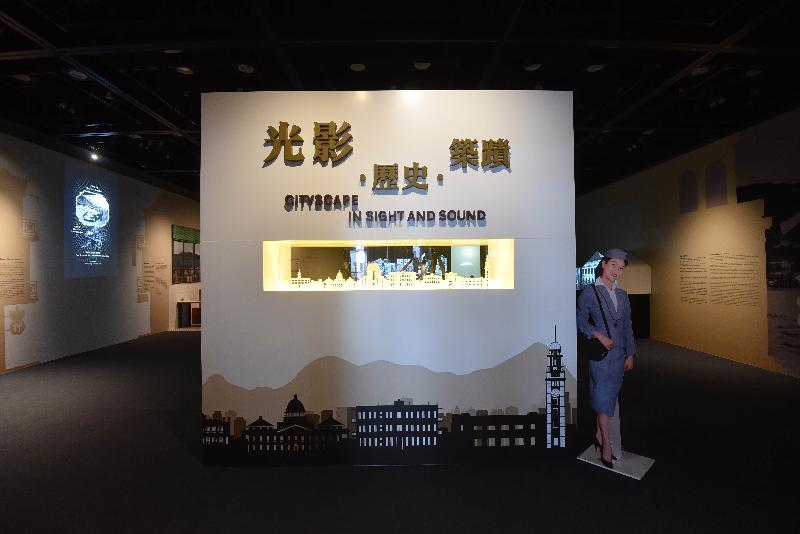
Film Archive’s “Cityscape in Sight and Sound” exhibition revisits Hong Kong’s past (with photos)

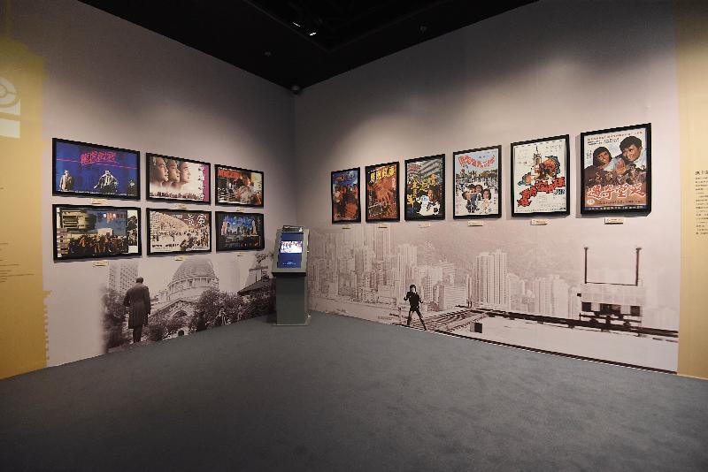
     The exhibition "Cityscape in Sight and Sound", organised by the Hong Kong Film Archive (HKFA) of the Leisure and Cultural Services Department, is being held from today (February 1) to May 5 at the Exhibition Hall of the HKFA. The exhibition offers visitors a glimpse of Hong Kong's past cityscape and landmarks through several hundred pieces of footage selected from the HKFA's archival film collection, including documentaries and dramas from the late 19th century to the 1960s, as well as film posters and digital album of production stills.    
 
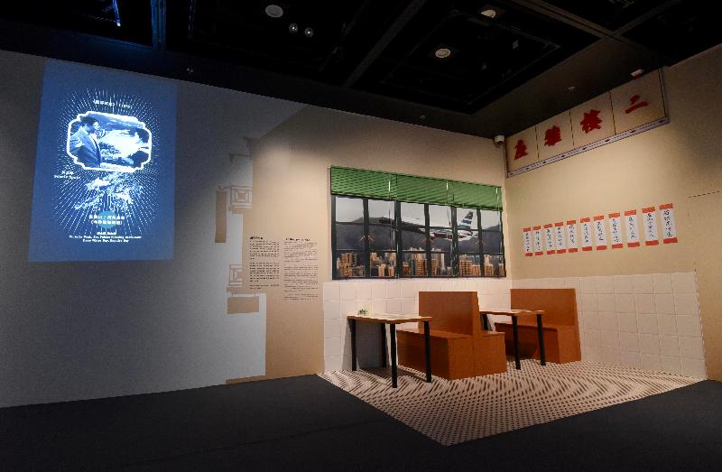
     The exhibition begins with the oldest documentary in the HKFA's collection, "The Edison Shorts", made by the Edison Company in 1898, which captured images of Hong Kong street scenes in late 19th century seen through the eyes of foreigners. Documentaries shot and donated by the former District Commissioner in the New Territories and Secretary for Home Affairs, Mr Denis Bray, record landscapes of the New Territories in the 1950s, which are being shown to the public for the first time. Films which were shot on location from the 1940s to 1960s record numerous landmarks that have disappeared or changed, such as Kai Tak Airport, the former Kowloon–Canton Railway terminus, the café Yucca de Lac, Lai Chi Kok Amusement Park and Queen's Theatre. While made for narrative purposes at the time, the scenes revealed in the films have become today's precious memories, as well as having historical significance.         
 
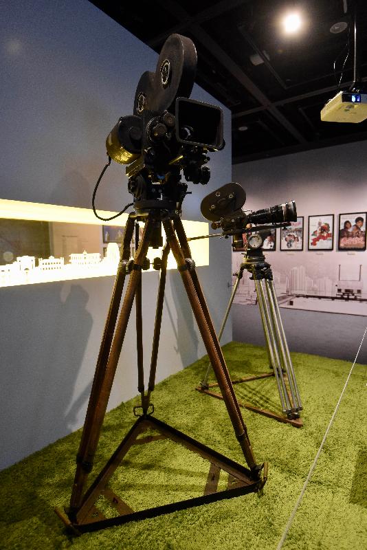
     In addition, the exhibition displays two old cameras commonly used in the 1950s and 1960s allowing visitors to better understand the difficulties faced by cinematographers in bygone days, who had to carry bulky equipment for location filming.
 
     To complement the exhibition, two seminars in Cantonese will be held by the HKFA at its Cinema. The first, entitled "Changing Times: Cityscape in Flux", will be held at 2.30pm on February 17, with film researcher, Gary Wong as speaker. Another seminar, entitled "Cityscape: Stories of Built Heritage", will be held at 2.30pm on March 17 and will be hosted by the former Chief Curator of the Hong Kong Museum of History, Dr Joseph Ting.
 
     Admission to the exhibition and the seminars is free. For details, please call 2739 2139 or visit www.lcsd.gov.hk/CE/CulturalService/HKFA/en_US/web/hkfa/programmesandexhibitions/highlights/highlights53.html.

Photo  Photo  Photo  Photo  Photo  


Crowd safety management measures and special traffic arrangements for Che Kung Festival

     Police will implement crowd safety management measures and special traffic arrangements to facilitate worshippers visiting Che Kung Temple in Sha Tin during the Che Kung Festival period.

Crowd safety management measures
——————————–

     A large crowd is anticipated to visit Che Kung Temple and Che Kung Festival Fair during the Lunar New Year period. Depending on the crowd condition, one-way pedestrian flow may be implemented at MTR Tai Wai Station and in the vicinity of Che Kung Temple, including Che Kung Miu Road and Chui Tin Street, between 10pm on February 4 and 6pm on February 8 to ensure public order and safety. Members of the public are urged to observe order and be patient while waiting in a queue.

Special traffic arrangements
—————————-

A. Road closure
     
     The following roads will be closed from 8pm on February 6 to 6pm the following day:

1. The slow lane of westbound Che Kung Miu Road between Sha Tin Tau Road and Chui Tin Street; and
2. The slow lane of southbound Chui Tin Street between Che Kung Miu Road and the entrance of Sun Chui Estate near Sun Fong House.

B. Cycle tracks closure

     The following cycling tracks will be closed from 8pm on February 4 to 6pm on February 8:

1. The cycle track along the western riverside of Shing Mun River Channel between Tsuen Nam Road and Che Kung Miu Road;
2. The cycle track along both sides of Che Kung Miu Road between Chui Tin Street and Sha Tin Tau Road;
3. The cycle track inside the subway system at the junction between Che Kung Miu Road and Chui Tin Street; and
4. The cycle track inside the subway system at the junction between Che Kung Miu Road and Sha Tin Tau Road.

     During the cycle track closure period, cyclists may use the cycle track along the northern riverside of Shing Mun River Channel between Lion Rock Tunnel Road and Shing Wan Road commuting to and from Sha Tin.

C. Suspension of car parks

     The public car park adjacent to Che Kung Temple will be suspended from 7am on February 4 to 8pm on February 8, and daily from 7am to 6pm on February 9, 10, 16, 17, 19, 23 and 24.

     The public car park adjacent to Greenview Garden will be suspended between 7am on February 6 and 8pm the following day.

     Members of the public are advised to make use of public transport to go to Che Kung Temple and Che Kung Festival Fair.

     Any vehicles found illegally parked within the precincts mentioned above will be towed away without prior warning.

     Actual implementation of the crowd safety management measures and traffic arrangements will be made depending on traffic and crowd conditions in the area. Members of the public are advised to exercise tolerance and patience and take heed of instructions of the Police on site.


Special traffic arrangements on Tolo Highway and Lam Tsuen in Tai Po

     Police will implement special traffic arrangements to facilitate the holding of Well Wishing Festival in Lam Tsuen during the Lunar New Year period.

A. Road closure and traffic diversions

     Lam Tsuen Heung Kung Sho Road between Lam Tsuen Pai Lau and Lam Tsuen Rural Committee Office will be closed and pedestrianized between 7am and 7pm daily from February 5 to February 19.

     The slow lane of northbound Tolo Highway near Wun Yiu leading to Tai Po (North) exit will be closed from February 2 to February 10. Vehicles heading for Tai Po (North) exit must use the nearside hard shoulder on the affected section of the road.  

     Depending on the prevailing traffic condition of Lam Kam Road, the affected section of northbound Tolo Highway may be further extended to Lam Kam Road Interchange between February 5 and February 10. All vehicles heading for Tai Po (North) exit and the Lam Tsuen Wishing Tree must use the nearside hard shoulder on the affected section of Tolo Highway. The slip road leading from Tai Po Tai Wo Road to northbound Tolo Highway will also be closed. Vehicles heading for the Lam Tsuen Wishing Tree from Tai Po Tai Wo Road must travel via southbound Tolo Highway, Kwong Fuk Interchange, eastbound Tai Po Road – Yuen Chau Tsai, Tolo Highway slip road, northbound Tolo Highway, the nearside hard shoulder on the affected section of northbound Tolo Highway, and Lam Kam Road Interchange. Vehicles approaching to the Lam Tsuen Wishing Tree from Fanling must travel via the above same route.

     During the road closure period, residents of Lam Tsuen Valley and Hong Lok Yuen heading for Lam Kam Road (Pat Heung bound) are advised to travel via Kwong Fuk Interchange, eastbound Tai Po Road – Yuen Chau Tsai, Tolo Highway slip road, the second lane of northbound Tolo Highway and Lam Kam Road Interchange.

B. Temporary no-stopping zones

     Vehicles are not allowed to pick up or drop off passengers and load or unload goods at the following locations between 7am and 7pm daily from February 5 to February 19:

– The access road to Fong Ma Po Village between Lam Kam Road and Lam Tsuen Rural Committee Office;
– Lam Kam Road between Lam Kam Road Interchange and the access road to Tong Min Tsuen, except for franchised buses and green minibuses;
– The access road to Tin Liu Ha Tsuen from She Shan Road; and
– She Shan Road.

     A temporary vehicle holding area will be set up between Lam Tsuen Public School and Hang Ha Po Tsuen to facilitate visitors alighting or boarding vehicles from February 5 to March 3.

     If the situation permits, public light buses and taxis may be allowed to pick up or drop off passengers on Lam Kam Road near Hang Ha Po Tsuen and Tong Min Tsuen. Plying for hire is strictly prohibited.

     To ensure road safety and smooth traffic flow, Police will continue to take traffic enforcement action during the Lunar New Year period, including issuing fixed penalty tickets and towing away illegally parked vehicles without prior warning. The operation will, in particular, target those causing danger to other road users, or seriously obstructing traffic flow and access of emergency vehicles.

     Actual implementation of the traffic arrangements will be made depending on traffic and crowd conditions in the area. Motorists should exercise tolerance and patience, and follow the instructions of Police on site.


Meetings of Legislative Council Committees

The following is issued on behalf of the Legislative Council Secretariat:

     No open or closed meetings of the Legislative Council (LegCo) Committees will be held in the LegCo Complex during the week from February 4 to February 8.


Draft Central District (Extension) Outline Zoning Plan approved

     The Chief Executive in Council has approved the draft Central District (Extension) Outline Zoning Plan (OZP).

     "The approved OZP provides a statutory land use planning framework to guide developments and redevelopments in the Central District (Extension) area," a spokesman for the Town Planning Board said today (February 1).

     The Planning Scheme Area (the Area), covering an area of about 46.70 hectares, is bounded by the Hong Kong Convention and Exhibition Centre Extension to the east, the Connaught Road Central/Harcourt Road corridor to the south, Connaught Place and Airport Railway Hong Kong Station to the west and the waterfront to the north.

     About 14.34 hectares of land is zoned "Open Space", which includes the waterfront promenade that extends from Man Yiu Street, existing Memorial Garden, Tamar Park and the open space reserved to the north of the Hong Kong Academy for Performing Arts.

     About 5.23 hectares of land is zoned "Comprehensive Development Area" for commercial development which extends from Statue Square and the Hongkong Bank Building towards the waterfront.

     About 0.36 hectares of land is zoned "Commercial" and is currently occupied by Citic Tower at Lung Wui Road.

     About 5.77 hectares of land is zoned "Government, Institution or Community" ("G/IC") for the provision of government, institution and community facilities serving the needs of the local residents and/or a wider district, region or the territory. It is also intended to provide land for uses directly related to or in support of the work of the Government, organisations providing social services to meet community needs, and other institutional establishments. Apart from the Central Government Offices and the Legislative Council Complex at the former Tamar Basin, the existing High Block and Low Block of the City Hall Complex, City Hall Car Park and the City Hall Annex Building are also zoned "G/IC".

     About 8.42 hectares of land is zoned "Other Specified Uses" for specified purposes, which includes military uses, waterfront-related commercial and leisure uses, piers and associated facilities and elevated walkway.

     The Area also provides land to accommodate essential strategic infrastructure. On the approved OZP, about 11.32 hectares of land is shown as "Road" to provide land for the above-ground road network.

     The approved Central District (Extension) OZP No. S/H24/9 is now available for public inspection during office hours at the Secretariat of the Board, the Planning Enquiry Counters of the Planning Department in North Point and Sha Tin, the Hong Kong District Planning Office, the Central and Western District Office and the Wan Chai Home Affairs Enquiry Centre.

     Copies of the approved plan are available for sale at the Map Publications Centres in North Point and Yau Ma Tei. The electronic version of the plan can be viewed at the Board's website (www.info.gov.hk/tpb).